Thursday, October 10, 2013

When Sea Lions Climb Hillsides (and swim with humans later)


"Go swim with the sea lions at the Reserve," said Andy from the harbor dive shop.

I was in for a surprise.  Sure enough, they got amazingly close.  But what I didn't expect to see were the sea lions on top of the hill -- way way above the water!

Dirt darkened by their shuffling flippers, carving out terraces and pathways, they milled around the hillside. What were they doing way up there?

On the opposite northwest side of the island, we observed these Hillside-Dwelling Sea Lions in a chaotic display:


Scores of sea lions were on the ridgeline. They made their way down to the rocks.  Their "highway" was like a natural Slip & Slide, which went through a huge flock of cormorants. The birds grew restless, flapping their wings. Poor things, they can't fly from a standing start.  So they intersected the path of the sea lions in order to jump off the cliff, like hangliders. This caused a massive traffic jam. A flurry of flapping wings and barking sea lions ensued for ten minutes.

What motivated these sea lions, I wondered, to carry their heavy blubbery bodies up to the top of the hill?  Perhaps it was a "King of the Hill" mating ritual that turned into a societal norm.  Who knows, in 10.000 years they might have erected mud huts and thrones!

"On a small island, one cannot question the ways of evolution," says the Pygmy Mammoth.


Back in their natural element, they came to investigate when I jumped into the water with a snorkle. The juveniles kept swimming closer, making last minute turns, as if challenging each other to get closer to this foreign creature. Their eyes were big and bright. Maybe even having fun?

That joy made the island feel alive.  I've been in places where things feel dead, decaying.  This felt exuberant, flourishing. Maybe that is a measure of how healthy Nature is... alive-ness.


Wednesday, October 9, 2013

Imaginary Fences in the Ocean


Father and son with lobster traps aboard the Merlin

"It's been a weak start so far," said the captain of the Merlin, about the lobster season this year. He was pulling up a cage with 5 good sized lobster. He conceded: "Although today is looking more promising."

Seasonal closures are a costly limitation for fishermen, but they allow the lobster population to strengthen. They are accepted and well-regulated.  However, there is a new rule in the game: marine protected areas (MPAs).


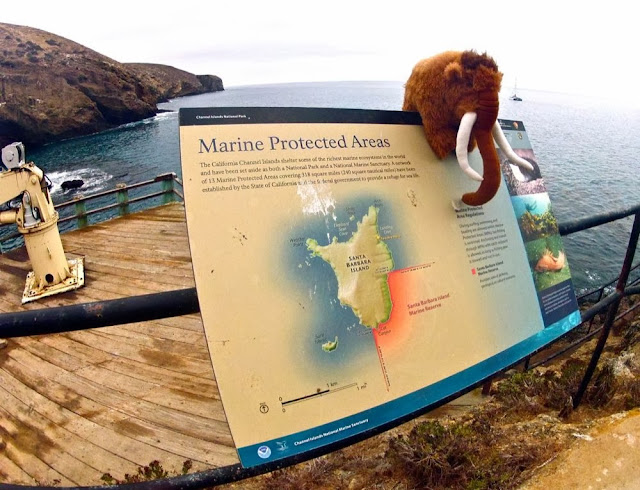
The Pygmy Mammoth doesn't like fences, but understands they make good neighbors.

Check out the map: the Marine Protected Area is the red rectangle extending from the south-east corner of the island. There is no fishing in this area.  Naturally, fishermen hate this. As a sailor, if someone told me I'm not allowed in some rectangle of coast, I would also be quite upset.  That is what fishermen are experiencing. 


Marine ecologists, however, tell us that MPAs are essential. Government policy has followed suit, and now there are lines in the ocean, shown by GPS coordinates. They are like imaginargy fences, where some or no fishing is allowed. 

Kelp bed south of the main anchorage, with Arch Point in the background

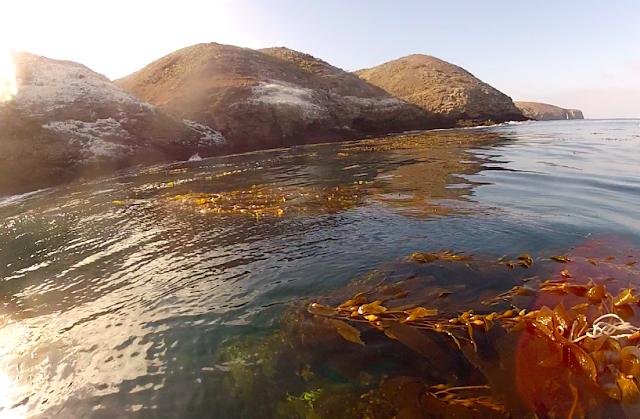
Later in the day, Chris and I paddled the tandem kayak from the main anchorage towards a nice kelp bed. We dove with our hawaiian slings, and came up with 2 perch and 1 fat sheepshead. Needless to say, we were outside of the reserve!  

After we gutted and scaled them, the fish turned into ceviche, a risotto, and a barbecue fillet dinner. It is good to be close to the source of our food, and get the atavistic feeling of a hunter-gatherer. That is a feeling that is vanishing from our world. Lobster fishermen like the captain of the Merlin are some of the last hunter-gatherers, living in the wild ocean to bring seafood to our plates. 


Sutil Island, on the right, is an rugged islet on the south-west corner of Santa Barbara Island

Sitting in Aldebaran, I looked south and imagined a fence running along the ocean with virtual "No Fishing" signs along it.  

Fences -- like seasonal closures and MPAs -- are unwelcome constraints for the free spirited fishermen. As management techniques, none are perfect. But they are attempts to keep seafood on our plates (and a life in the ocean) into the future. 


Government Shutdown and Arrival in SB isle

Happy to get off Aldebaran (that little speck at anchor in the background), Pygmy Mammoth admitted to being a little sea sick.

The Pygmy Mammoth made it to Santa Barbara Island!

We were greeted with the following sign:

"Due to the federal government shutdown, this facility is closed."

Anarchy is not my forte, but after 11hrs of sailing, I wasn't about to turn back. I climbed the ladder to the rudimentary dock, the only landing on the island.

I first heard the news as we fueled Aldebaran in the harbor, just prior to departure: "Does this mean the IRS is also closed?" laughed the fuel dock attendant. We were raising sail ten minutes later, salt spray on our eyes, laying rest our worries about societal collapse. 


A warm welcome from one of our nation's most inaccessible National Parks

The bureaucratic beast would rear up its head soon enough -- we were still applying for access to the Navy-controlled San Clemente and San Nicolas islands. But this caught me off guard.  A beloved National Park, closed, after all this effort!

"What do you think about all this?" I spoke aloud to the island, now solidly under my feet. 

A memory came to me. Do you know that book about how Nature comes back when humans are gone?  That possibility is fertile in this isolated chunk of land. But is that what the island wants?  Should we be good stewards of the land; is our restoration work bringing real benefit?


Prompted by our government's vacation, these were good questions to start the journey.  Restoration costs millions of dollars. We need to know why we are doing this.

Spectacular and controversial programs have occurred in each of the eight channel islands, with varying levels of success and challenges. I hoped to learn the deeper Why and How of Restoration, by visiting them in my sailboat; ultimately, to appreciate these fantastic islands and to see what they teach us about the art of dealing with change.

Was there anyone on this island to discuss this question, or would I just keep talking to myself?

After walking up the hill, I found two people. 

Sunday, October 6, 2013

Four crew... 63 miles to SB island

Here's our crew and route for the first leg of the trip:


The voice of unreasonable wisdom was from my own dad, Bob Beadle, who joined us on the trip to "keep an eye on things."

He steered Aldebaran when we were flying at 8 knots enroute to Santa Cruz island, where we made a pitstop. When conditions aren't thrilling, he gets bored and can be found reading "Voyage for Madmen" inside the cabin.   He makes a mean risotto and secret pancake recipe, as we discovered on days 2 and 4. 


Chris Colajezzi is a lifeguard from Los Angeles joining us on the October cruise, a solid guy, chill, hard-working, good company. On the 7hr, 40mile stretch across lonely ocean to Santa Barbara Island, he was fixing the man-overboard pole and rigging the life ring. Safety first!  Chris seems right at home repairing things underway; because that's how we roll on Aldebaran.


The good ship Aldebaran wouldn't be sailing the high seas without Ed's persistence for "gumption", a quality he brings as director of the Santa Barbara Bicycle Coalition (and boat partner). Gumption is togetherness; it is lastingness; it is maintenance-free-ness.  He grew up sailing with his dad in Catalina; the journey south is a long standing dream, uniting his past, environmental work, and life in Santa Barbara. 


This is me.  I remember the summers that I spent with my grandparents in a small cabin in an island. Since then, islands have always fascinated me. Surrounded by ocean, I felt butterflies in my stomach when I sighted Santa Barbara island in the haze. Then she grew in front of us. Just 63 miles south of Santa Barbara (the town), she is rarely visited, as most people sail straight to Catalina. It is a forlorn, water-less land. But like a poor man's oasis, it is full of life when we look closer. 


Day 1: Santa Barbara to Santa Cruz Island (23nm). The wind was 12-15 knots, beautiful sailing, clear skies, departing 4pm, arriving 7:30pm at Smuggler's Cove. 
Day 2: Santa Cruz Island to Santa Barbara Island (40nm). Light north breeze had us motor-sailing south to make sure we'd arrive before dark. Departure 10am, arriving 5pm at the main landing in Santa Barbara Island.
Day 3-4: In Santa Barbara Island, anchored at the Main Landing, we circumnavigated the island twice. 

Tuesday, October 1, 2013

Departure Day!

.

15 photos from Santa Cruz

Ah... Santa Cruz island.  A more pristine and gorgeous island would be hard to duplicate!
One quarter National Park, three-quarters Nature Conservancy, this island is an amazing playground and fascinating story in restoration.


15 photos from Santa Rosa

Santa Rosa island is home to the famous 1994 excavation of the pygmy mammoth, the most complete skeletal remains found of the species!

It is also home to the oldest human remains found in North America, dating 13,000 B.C., discovered in 1959 (the "Arlington Springs Man").  The island is a remarkable place of archeology and history.

It takes the full brunt of the open ocean swell and wind, but is large enough to create a protected side where we can anchor in the (sometimes) calm conditions. Its anchorages are wider and less sheltered than those found on Santa Cruz island, but the abundant flora and fauna, and wild scenery makes it a fantastic place to visit.


Where is Santa Rosa Island?

  • 26 miles south of the Gaviota coastline
  • 6 miles west of Santa Cruz island
  • It is 15 miles wide by 10 miles long

Two interesting facts:
  • The Arlington Springs Man (the oldest human remains found in North America) shows that early Paleo-Indians had capable watercraft, and re-enforces the "coastal migration" theory of peopling the Americas from Asia. 
  • The Chumash called the island "Wima" (driftwood) as they would find the valuable redwood logs from which they built tomol plank canoes to cross from the mainland to the islands. 

Sources: